
From idyllic pristine beaches with breaker point waves perfect for surfing, to a diverse and serene ecology with world-class heritage attractions, you will love the tinkle of Ghana’s west coast where balmy adventure laden itineraries await.
Whether you just want time out to unwind – and you may lounge on the beach at any of the many hotels and lodges dotted along its shore, or you want your agile self-occupied with any of the many pursuits available, an escapade this direction provides just the occasion!
Off the highway, one of the feeder roads on the left leads to the southernmost tip of Ghana at Atinkyin, where a 1925 (later installed solar powered) Lighthouse situated at Cape 3 Points will give you breathtaking panoramic views of Ghana’s only coastal rainforest reserve, many rolling hills and the Atlantic Ocean. PaJohn Bentsifi Dadson recently joined a bespoke tour there curated by Native Adventures, producers of the WangoWango travel experience, and reports having a rollicking time.
Westward of the Western Regional capital of Sekondi-Takoradi, driving along the Trans–West African Coastal Highway towards the western border town of Alubo, any of the feeder junctions off on the left will take you to a coastal settlement where you can be sure to find a spot on the beach that resonates with just what your doctor ordered.
Busua must be the most popular beach in these parts. What with its bragging rights to being the location for the famous 3-star Busua Beach Resort, as well as the destination for the annual Asa Baako Music Festival.
Until recently a sleepy quixotic town, Busua has grown rather rapidly in the last few years into a bustling settlement popular with the very many young European backpacker tourists who visit Ghana in droves.
A fishing community, it is some 35km west of the regional capital and flanked to its west by Dixcove, which is the site of the 1698 English-built Fort Metal Cross, which dominates the town from a bluff located on the eastern side of the coastal settlement in the Ahanta West district. To the east, also quite close, is Butre, another settlement that boasts of another fort, the 1656 Dutch built Fort Batenstein.
Our itinerary started at Busua, where we arrived late at night and checked into chalets at the resort. Modern, well-appointed and self-contained, our chalets had clear views of the ocean, and though it was close by, the nighttime shadows concealed how close, and its magnificence.
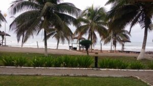
Morning revealed a stunning stretch of clean sandy beach and an expansive blue sea a short distance from the porch, a couple palm trees away. Its waves made rhythmic loud splashes that worked a balm into the soul, with a subtle reminder that time never stops. Throughout the night, even in the sealed air-conditioned room, you could hear it roll. And now, as I gazed upon it, it sturdily charged my elation.

Busua has a looming calm that gives the township a certain ambient flair. It must be that small island with a bit of a hump that sits a distance into the ocean. It is a very distinctive feature which adds to the romance of this resort town.
After a hearty breakfast, we make our way back to the junction town of Agona and join the transnational highway that links 12 West African coastal nations, from Mauritania in the north-west of the sub-region, to Nigeria in the east, with feeder roads that lead inward to two landlocked countries, Mali and Burkina Faso.
‘Atinkyin’, meaning ‘the salt has been taken out’ is the original name of the settlement at the southernmost tip, referred to as Cape Three Points which has become the defacto name of the village whose population is said to be about 500.
The people here belong to the Ahanta ethnic group, who occupy land spanning from Beposo to Ankobra in western Ghana.
Once upon a time, they were a regional power in the form of a confederacy of chiefdoms which had come in early contact with the European nations settling on the Gold Coast for the purpose of trade.

Belonging to several Congo-Niger languages such as Igbo in Nigeria, Edo in Benin and all the Akan languages stretching across the South of the Sahara Desert from Togo to Cote D’Voire, Ahanta is one of the sub units of several kwa languages across the forest belt of Sub-Sahara Africa, as old Methusalah but sadly a language that now faces possible extinction in the next 10 or 20 years as a research conducted by the University of Cape Coast recently showed.
The indegenes are not speaking their language and for that matter, are not teaching their children to pass it on to the generations that may come after them which is rather sad. Sekondi -Takoradi, for instance, has completely lost its Ahanta taste and fragrance.
A shorter route to the site of the lighthouse on the eastern approach through the vast rubber tree plantation passing the village of Charvene would have taken less than an hour to get there but for recent rains that had rendered it impassable.
This is why we used the western approach, near Akitakyi, more popularly known as Princes’ Town. Though equally bad, the road here is dryer, and after a little over an hour, we arrive at the hilltop spot, where the lighthouse is situated.
Ghana lies between latitudes 4° and 12°N, the northernmost point being at a town called Pulmakong. There, the vegetation is Sahel Savannah, pure grassland. Here in the south, we were in a unique environ where a 360° turn gives you remarkably different vistas, from ocean to thick forest.
The hill jets out into the ocean to form the tip. The grounds of the hill has natural carpet grass, with some large rocks scattered around it. On the side which enters the sea, the rock becomes boulders with chisel edges on which waves hit, making huge splashes. It is curious terrain and a thrill trying to navigate. Afraid of slipping, and being ever so careful, a humongous wave has just splattered and rendered me completely wet. It’s exhilarating!
I return to the grounds to find that the WangoWango gang have laid out a spread of some delectable fare, with a grill stand on which some marinated pork and chicken is cooking.
Where did all this gear come from? We are a group of 12 in a 15-seater van packed with stuff. And while the 9 of us guests scattered to explore the site, the two escort assistants and driver quickly pulled out portable outdoor camping and cooking accoutrements to set up a long dining table with identical chairs, for a picnic.
That was a surprise, how swiftly they laid everything including warm jollof rice and a slow cooked lamb stew which is on a makeshift fire to heat up. It was a feast that ensued and our bellies filled, we spread out on blankets in the shade, just shooting the breeze and actually enjoying the seaside flurry of air.
Earlier, I had gone up the spiral staircase inside the lighthouse to the top to take in fresher air and the scenes from the higher height. It was simply stunning.
Before dusk, we set off back to Busua, arriving in good time to shower and meet up in flowing white garments as advised in our itinerary, on the shore close to where the sea recedes, for a traditional drumming entertainment beside a huge bonfire.
With waves blasting away and drummers plummeting their instruments, we were served a local favourite, atseke, a couscous like staple made from cassava and grilled spicy tilapia to top off the night. Two generous glasses of red wine helped settle things before retiring to bed, making a note to repeat a booking of any of these curated bespoke experiences with this WangoWango Native Adventures gang.


